Tab Process
The Process tab allows you to define survey2gis commands and execute each.
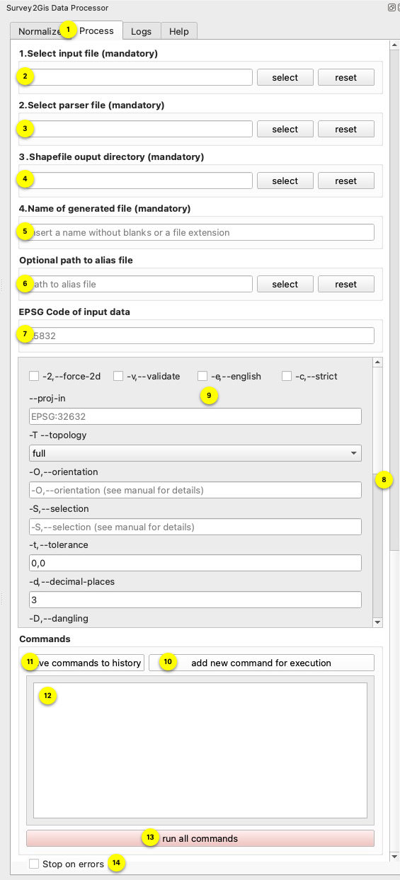
- Open Process
Click to open the Process tool. - Select the input file
The input file contains the merged measurement data. This field is automatically set if the Normalize tab was used to prepare your data. - Select a parser file
Each survey2gis command requires the specification of a valid parser file. If you are unsure, consult the survey2gis help pdf linked in the Help tab. - Directory for shapefiles
Each call of survey2gis creates shape files as intermediate format. These files are then packed into a geopackage.If a file named
keep_filesexists in the plugin directory, the shapefiles are not deleted which helps when Find the plugin path: Go toSettings > User Profiles > Open Active Profile Folder, then open folderpython. Here you will find all installed plugins. Navigate to thes2g_data_processorextension subfolder where thekeep_filesneeds to be placed. - Name of the generated file
survey2gis generates a shape file for each layer as mentioned in point 4. This field defines the name of the shape file, i.e. the name of the layer in the final geopackage that is loaded in QGIS. When using qml files, make sure that the style and layer names are identical. - Path to the alias file
survey2gis limits the field names to 10 characters. We can work around this by defining an alias file. This applies globally for all command calls and must be created as follows:[aliases] key=value ...Where
keyis the name of the defined parser field andvalueis the new name. Please note that your qml style may no longer work correctly or may need to be adapted. - EPSG code
The following scenarios exist with regard to the projection.- The user knows in which projection the input data is available and sets an EPSG code in this field. As a result, survey2gis does not take care of a new projection, but the extension writes the given EPSG code into the resulting geopackage for each layer. QGIS reads this information and will be able to integrate the layer correctly without asking.
- The user knows in which projection the data is available and uses the command options
--proj-inand--proj-out. This causes survey2gis to re-project the data. The extension reads the value in--proj-outper command and writes it as an entry in the geopackage. QGIS understands this information and will be able to include the layer correctly without asking. - The user executes the commands, leaves the field empty and makes no entry for
--proj-inand--proj-out. In this case, the extension knows nothing about a projection and writes the data to the geopackage without it. Depending on how QGIS is configured, it will ask for the projection or use the projection of the project. See the QGIS project settings.
- Pay attention to the scrollbars
- Command options
Here, the survey2gis options can be set for each command call.Unsure? Look in the Help tab!
- Add command
After a command has been defined in the fields above, this button adds the command to the code field (12) for execution. Each command needs to be defined in a separate line. The commands are proccessed sequentially in the order they are defined. - Save commands
When adding a command via the button (10), all commands created are automatically saved in a text file in the plugin directory under the namecommand_history.txt. When restarting, they are loaded from here and automatically added to the code field (12). If you make changes directly in the code field, you can use this button to write all currently defined commands of the code field to thecommand_history.txtfile.Find the plugin path: Go to
Settings > User Profiles > Open Active Profile Folder, then open folderpython. Here you will find all installed plugins. Navigate to thes2g_data_processorextension subfolder to see thecommand_history.txtfile. - Code field
This field contains all created commands that are processed when executed. - Start process
Pressing the button starts the processing of all commands. If successful, the data is written to the geopackage in the defined output folder and loaded into QGIS. If something goes wrong, visit the Logs tab and look for errors. - Stop on errors
When this checkbox is enabled, the extension will pause processing if it encounters “ERROR” in the Survey2GIS log output. Note: Errors can occur even during normal operation - for example, when an input file contains no processable data. In such cases, you can uncheck this option to allow the processing to continue with subsequent commands.